
[:nl]Het De Silleplein wordt heringericht. Het plein zou ongeveer op dezelfde manier heringericht kunnen worden zoals het nu is, maar misschien kan het groen en de openbare ruimte ook groter gemaakt worden door aan één zijde van het plein de straat af te sluiten voor verkeer. De bewoners van het plein, omliggende straten en de wijk waren verdeeld over hoe het plein het best ingericht zou kunnen worden. De gemeente wil daarom een experiment uitvoeren om te ervaren wat afsluiting van de straat zou betekenen.
Het experiment bestaat uit het tijdelijk afsluiten en inrichten van de straat (maximaal 3 maanden), en het gebruik van de openbare ruimte monitoren en evalueren. De tijdelijke inrichting is makkelijk aan te leggen en weer weg te halen en laat het bestaande plantsoen intact.
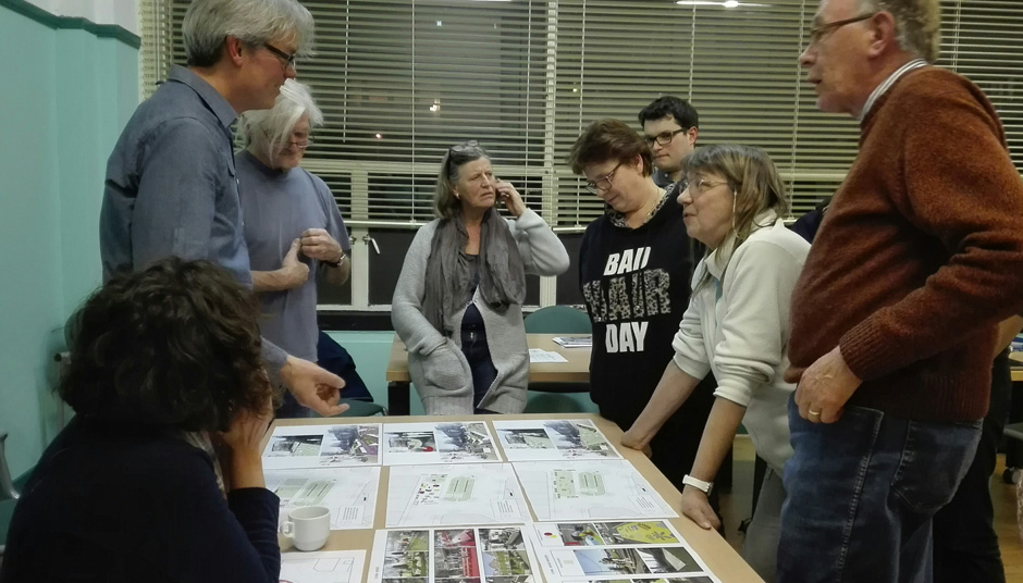
Op maandag 6 maart is er een bijeenkomst geweest met enkele bewoners rondom het plein, de pleinenwerkgroep, wijkberaad, de gemeente. Wij begeleiden en ontwerpen het experiment. Tijdens deze bijeenkomst is onder meer gesproken over waarom het experiment plaatsvindt, bezwaren en voordelen van verschillende varianten, en er is gesproken over de concrete inrichting van het plein tijdens het experiment.[:en]The experiment to temporarily transform De Silleplein at The Hague started last Monday. At an evening meeting, we discussed together with the interested neighbours and the municipality the possibilities to transform the square. We conversed about the fears and dreams for the transformation of the square that will take place from May until July 2017. In the next meeting, we will present the design in which we will spatialize the opinions of the group, as well as presenting the criteria and methods to evaluate the positive and negative impact of the transformation towards the definitive design by the municipality of The Hague.[:es]El experimento para transformar temporalmente la plaza Silleplein en La Haya empezó el lunes pasado con una reunión con la comunidad. Durante esta reunión conversamos con los vecinos sobre los miedos y deseos que tienen para la transformación de la plaza. El experimento transformará la plaza durante los meses de mayo, junio y julio. En la proxima reunión con la comunidad presentaremos el diseño que surge de las conversaciones del lunes así como la forma como vamos a evaluar el impacto positivo y negativo de la transformación temporal. Los resultados de la evaluación serán en insumo para el diseño definitivo por parte de los urbanistas y paisajistas del municipio.[:]
![[:nl]Groene Corridor Pereira[:en]Green Corridor Pereira[:]](https://www.urbanos.nl/wp-content/uploads/URBANOS-WENR-Pereira-Green-Corridor.jpg)
![[:nl]Plein voor buurt[:en]Neighbourhood square[:]](https://www.urbanos.nl/wp-content/uploads/URBANOS-Galjoen-perspectief.jpg)
![[:nl]Future City op het European Forum Alpbach[:en]Future City at European Forum Alpbach[:]](https://www.urbanos.nl/wp-content/uploads/Forum-Alpbach.png)
![[:nl]Tijdelijk plein[:]](https://www.urbanos.nl/wp-content/uploads/Leiden-tijdelijk.png)
![[:nl]Genereus Stadmaken![:en]Generous city![:]](https://www.urbanos.nl/wp-content/uploads/SLOWFestival-Genereus-Groningen-pink.jpg)